The City of Mississauga is conducting an aerial spray this spring. The spray will target and manage Lymantria dispar dispar (LDD), formerly known as gypsy moth, in affected city neighbourhoods. The spray is weather dependent and is currently set to happen between April 25 to June 12, 2022, from 5 and 7:30 a.m. The spray area consists of private and public land in Wards 1, 2, 3, 5, 6, 7, 8, 9, 10 and 11 and is roughly 2,100 hectares (5,189 acres).The total cost to implement this year’s spray is estimated at $3 million. Read More
On Wednesday, April 6, the City of Mississauga is holding a live, virtual information session on how we’re tackling the housing crisis in our City and working to make housing more affordable.
Residents will learn about the actions Mississauga is taking to create more housing supply and make it more affordable. The session will also address the City’s concerns with approaches to housing affordability and planning, as proposed by the Province’s Housing Affordability Task Force, which could significantly change Mississauga neighbourhoods without making housing more affordable.
The event will include a Question & Answer session. Read More
This April, celebrate Earth Day and contribute to a greener Peel by reducing the number of batteries sent to landfill.
From April 11 to April 22, residents are encouraged to put their single-use and rechargeable batteries out for spring battery collection.
Thanks to Peel residents, we’ve collected over 140,000 kgs of batteries since the start of the program in 2016 to ensure safe and responsible recycling of used batteries.
Free curbside battery collection happens in Peel each spring and fall, providing residents with a convenient way to dispose of their batteries safely. Read More
Like many municipalities, Mississauga is facing a housing crisis. Costs continue to climb and too many people are being priced out of the market. In response to the housing crisis, the Government of Ontario commissioned a Housing Affordability Task Force to make recommendations about how to address housing supply and affordability.
While the City of Mississauga supports building more housing, we are concerned that the recommendations in the Task Force miss the mark. In fact, if the recommendations are implemented as currently written, they could have a devastating effect on our neighbourhoods without making housing more affordable.
Many of the recommendations are a ‘one-size fits all’ for the entire province and could make our neighbourhoods look like this:
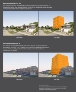
Mississauga supports infill development and greater density in our neighbourhoods, but where it makes sense and with proper consultation through the local planning process. One-size-fits-all housing solutions just won’t work. Public consultation and local planning is important. We want to plan our communities together.
Tell Your MPP to Protect Local Communities The City’s response to the Task Force recommendations has been shared with the Minister of Municipal Affairs and Housing to consider before introducing legislation.
The City does not support recommendations that:
· Limit public consultation on future developments
· Lower design standards and erase heritage
· Reduce our ability to plan our city in our own way
· Create a financial risk for the development of new infrastructure and parkland in our city and put the burden for growth on existing taxpayers If you want to take action, tell your MPP that one-size-fits-all planning doesn’t work. More public input is needed before final decisions are made.
Mississauga has a plan to build more housing and make housing more affordable. Learn more at Mississauga.ca/housing.
March 24, 2022
Today at Regional Council, I seconded a motion that will extend the Residential Rat Control Subsidy Program until November 30, 2022 to better evaluate the demand of residents.
Motion Below:
Whereas Regional Council at its meeting on October 8, 2020 approved a 12-month Rat Control Rebate Pilot Program and a Construction Abatement Program (Resolution 2020-812);
And whereas, the Region of Peel implemented a Residential Rat Control Subsidy Pilot Program (the Pilot Program) that started January 1, 2021 and it set to end on March 31, 2022;
And whereas, the Pilot Program findings outlined in the report of the Commissioner of Public Works, listed on the March 24, 2022 Regional Council agenda titled “Residential Rat Control Subsidy Pilot Program”, demonstrated lower than expected community uptake of the subsidy;
And whereas, community focus on COVID-19 may have posed as a distraction to resident participation;
Therefore be it resolved, that the Region of Peel Residential Rat Control Subsidy Pilot Program be extended in the current format as outlined in the subject report until November 30, 2022 to better evaluate subsidy demand;
And further, that staff monitor the issue and report back to a future meeting of Regional Council on the Rat Control Rebate Pilot Program prior to implementation of the program beyond the pilot stage;
And further, that construction abatement, including pest control measures, be adopted as a standard inclusion for future Region of Peel construction project tenders;
And further, that the construction abatement programs continue to be funded from capital projects;
And further, that an additional $100,000 required to meet previous years’ subsidy levels and fund potential subsidy uptake be added to remaining capital funds available from the previously approved budget until the program can be evaluated after the pilot stage.
INTERRUPTION DETAILS
Date: and Time: Thursday, March 31, 2022 from 9:00 a.m. to 5:00 p.m.
Location: 934 Goodwin Road, Mississauga
Addresses Affected: 899 to 946 Goodwin Road, 671, 677, 681 and 684 Byngmount Avenue (24 houses affected) Read More
Click the link to view the slideshow from my Community Virtual Meeting on Mach 24, 2022: PC Foundation Repairs Public Ward 1 Community Meeting
In Person and Virtual Public Meeting
RECOMMENDATION REPORT NOTICE
City of Mississauga
Wards 1-11
Parking Regulations Study
File: BL.01-PAR
City’s Proposal:
To consider changes to the Mississauga Zoning By-law regarding off-street parking requirements (e.g., parking on private and public properties as a result of new development or re-development). The purpose of the amendments is to revise policies for parking supply and to update the vehicle parking regulations in the Zoning By-law based on a parking precinct approach as recommended in the City’s Parking Master Plan and Implementation Strategy and the Parking Regulations Study. Read More
A message from Metrolinx:
- On weekdays, we’re adding more weekday evening trains, giving you 30-minute service between Aldershot GO and Union Station, all day long. The last eastbound and westbound trips of the day will be extended to serve West Harbour GO.
- On weekends, the first westbound trip of the day will depart Union Station at 7:15 a.m., with trains departing every 30 minutes until 12:45 a.m. The first eastbound trip of the day will depart Aldershot GO at 5:25 a.m., with trains departing every 30 minutes until 11:25 p.m.
A reminder, there will be reduced Lakeshore West service on April 3 and 10:
GO buses will replace most trains on the Lakeshore West line on Sunday, April 3 and 10 to carry out important work for the Hurontario LRT that can only be completed when trains aren’t running.
Please plan ahead for your trip using gotransit.com and triplinx.com